
Swan River
A longboat departed from the French vessel the Naturaliste to explore the Swan River. The expedition was led by François Heirisson and reached the mouth of the river on 17 June 1801. Joseph Bailly, mineralogist, reported that after running aground three times they managed to pass through the bar and into deeper water. A multitude of pelicans were found in this part of the river and the shore was covered with white, gelatinous, transparent jellyfish left by the tide. The ground was composed of sand dunes and sandy limestone rocks. Growing on the dunes were various shrubs, some of them flowering. Lots of eucalyptus and flocks of land birds, mostly elegant parrots, animated the otherwise unknown, deserted, wild shores.
As the party travelled up the river through what is now Fremantle, East Fremantle and Blackwall Reach, they noted the steep limestone cliffs which lined one, then the other side of the Swan River, at one point forming a great circular wall topped with vegetation. Everywhere the rock was incrusted with shells, roots, petrified tree trunks, giving the impression of ancient ruins. The landscape was otherwise flat, with low hills visible a long distance away. Soon the river opened into a relatively shallow basin, surrounded by low-lying land. On the left bank they observed the opening to what is now the Canning River, which the party assumed communicated with the sea. They named it the Entrée Moreau after one of the midshipmen in the party. They camped on a little sandy beach at the foot of a steep cliff where they felt safe from attack. Climbing to the top of the hill (now known as Mount Eliza), they enjoyed a pleasant view: on one side they could see the upper reaches of the river extending towards distant mountains, on the other the lower reaches extending towards the ocean. Both shores seemed to be covered in beautiful forest.
The terrain the Frenchmen were passing through was low and swampy, a layer of coarse sand covering a bank of red, clinging clay. This change in the makeup of the soil meant that rain water was trapped on the surface of the soil, causing rivulets of fresh water to join the river and decrease its salinity. The group camped overnight by the river (probably near present-day South Guildford). Heirisson and Moreau ventured up a small stream for half an hour and found a human footprint whose size astonished them. The next morning (19 June), after filling their casks with fresh water from a well that Bailly had discovered the day before, and which seemed to him to be man-made, they continued up the river. They had hoped to reach the source of the river, but realised, after travelling all day, that it was still far away and that they were running out of provisions.
On the 20th they started back down river. On the 21st they got stuck in the shallows again. They were forced to build a raft onto which they unloaded their heavier cargo. The whole crew had to get into the water and push the boat. After 13 hours of struggling in mud up to their waists, starving, exhausted, a breeze finally helped them to sail the boat out of this difficult spot. Night fell and the party went ashore where they suddenly heard a terrible noise, like the roar of a bull, coming from the reeds. They froze in terror and lost all desire to spend the night ashore, going back to the boat where they spent a sleepless night in the rain and cold. The next day (22 June) everyone was forced back into the water to drag the boat. After a while they stopped to light a fire and warm themselves up. They continued down river and finally reached the mouth, and in the evening were back on board the Naturaliste, exhausted and starving.
Heirisson Island, over which The Causeway now runs between East Perth and Victoria Park, retains its name given in 1801 after François Heirisson. The island is also known by its Aboriginal name of Matagarup.
A longboat departed from the French vessel the Naturaliste to explore the Swan River. The expedition was led by François Heirisson and reached the mouth of the river on 17 June 1801. Joseph Bailly, mineralogist, reported that after running aground three times they managed to pass through the bar and into deeper water. A multitude of pelicans were found in this part of the river and the shore was covered with white, gelatinous, transparent jellyfish left by the tide. The ground was composed of sand dunes and sandy limestone rocks. Growing on the dunes were various shrubs, some of them flowering. Lots of eucalyptus and flocks of land birds, mostly elegant parrots, animated the otherwise unknown, deserted, wild shores.
As the party travelled up the river through what is now Fremantle, East Fremantle and Blackwall Reach, they noted the steep limestone cliffs which lined one, then the other side of the Swan River, at one point forming a great circular wall topped with vegetation. Everywhere the rock was incrusted with shells, roots, petrified tree trunks, giving the impression of ancient ruins. The landscape was otherwise flat, with low hills visible a long distance away. Soon the river opened into a relatively shallow basin, surrounded by low-lying land. On the left bank they observed the opening to what is now the Canning River, which the party assumed communicated with the sea. They named it the Entrée Moreau after one of the midshipmen in the party. They camped on a little sandy beach at the foot of a steep cliff where they felt safe from attack. Climbing to the top of the hill (now known as Mount Eliza), they enjoyed a pleasant view: on one side they could see the upper reaches of the river extending towards distant mountains, on the other the lower reaches extending towards the ocean. Both shores seemed to be covered in beautiful forest.
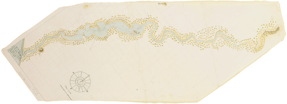
Above:
The first detailed map of the Swan River, drawn by François
Heirisson in 1801
click here for full zoomable version of Swan River map
click here for 1801 Swan River map labelled with modern suburb names
On the 18th, at daybreak, the party continued up the river, meeting
flocks of pelicans. They killed two. They soon ran aground in soft,
thick, clinging mud and spent much time dragging their boat through
it. The river was barred at this point by a group of low, swampy
islands which they named Iles Heirisson after their commanding
officer. After passing these islands they saw black swans for the
first time, swimming majestically on the water. They killed several.
Bailly reported that the birds were completely black, except for
their white wing tips and their red beak. A few moments after their
death the beak turned black.click here for full zoomable version of Swan River map
click here for 1801 Swan River map labelled with modern suburb names
The terrain the Frenchmen were passing through was low and swampy, a layer of coarse sand covering a bank of red, clinging clay. This change in the makeup of the soil meant that rain water was trapped on the surface of the soil, causing rivulets of fresh water to join the river and decrease its salinity. The group camped overnight by the river (probably near present-day South Guildford). Heirisson and Moreau ventured up a small stream for half an hour and found a human footprint whose size astonished them. The next morning (19 June), after filling their casks with fresh water from a well that Bailly had discovered the day before, and which seemed to him to be man-made, they continued up the river. They had hoped to reach the source of the river, but realised, after travelling all day, that it was still far away and that they were running out of provisions.
On the 20th they started back down river. On the 21st they got stuck in the shallows again. They were forced to build a raft onto which they unloaded their heavier cargo. The whole crew had to get into the water and push the boat. After 13 hours of struggling in mud up to their waists, starving, exhausted, a breeze finally helped them to sail the boat out of this difficult spot. Night fell and the party went ashore where they suddenly heard a terrible noise, like the roar of a bull, coming from the reeds. They froze in terror and lost all desire to spend the night ashore, going back to the boat where they spent a sleepless night in the rain and cold. The next day (22 June) everyone was forced back into the water to drag the boat. After a while they stopped to light a fire and warm themselves up. They continued down river and finally reached the mouth, and in the evening were back on board the Naturaliste, exhausted and starving.
Heirisson Island, over which The Causeway now runs between East Perth and Victoria Park, retains its name given in 1801 after François Heirisson. The island is also known by its Aboriginal name of Matagarup.


The Freycinet Collection was purchased for the State Library of Western Australia at an auction in London in 2002
You can support future acquisitions by making a tax-deductible donation to the State Library of Western Australia Foundation
Teachers! Click here to download our Freycinet Australian Curriculum education resource ( PDF / 9.34 MB )