Depuch Island
On 27 July 1801 the French vessel Géographe sighted land. They were off the Western Australian coast midway between present-day Karratha and Port Hedland. Opinion on board was divided as to whether this land was an island(s) or the mainland. Some of the charts captain Nicolas Baudin was carrying suggested that they were looking at the mainland; only their naval chart indicated it was islands. The Géographe anchored and at 9 am Baudin sent an expedition, with naval engineer François-Michel Ronsard in command, to reconnoitre the land and make soundings. In his official report, Péron remarked that the naturalists on board the Géographe implored Baudin to be allowed to go ashore, but were not given permission. Another small boat, with a midshipman in command, was sent off to make soundings to the east.
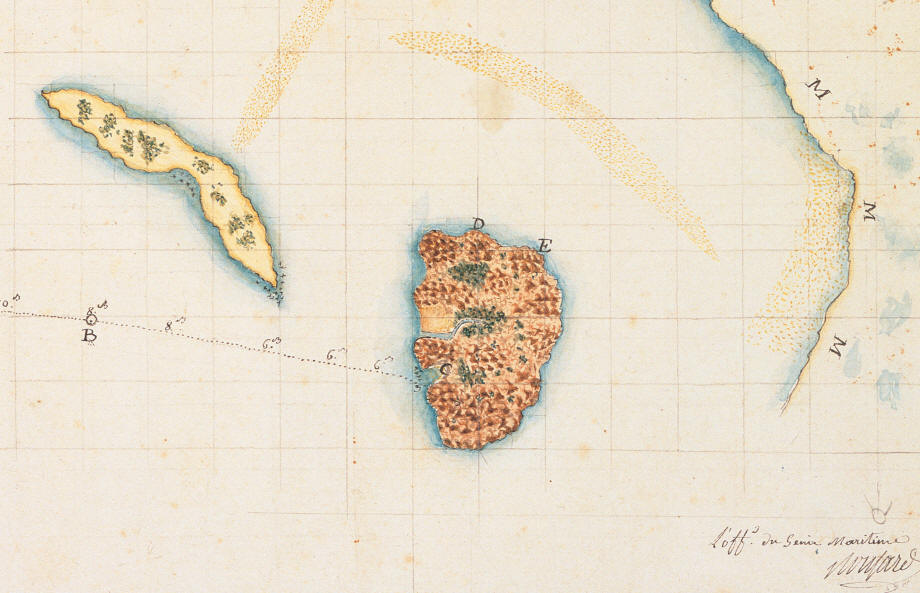
The initial anchorage of the Géographe is represented on this map by the anchor symbol and the letter A on the left hand side. The progress of Ronsard's expedition in the large boat as it approached the shore, taking depth soundings every mile, is indicated by the dotted line with depth readings at regular intervals. The letter B indicates the position of the boat at midday.
As the other, smaller boat went too far from the Géographe to be able return by nightfall, Baudin set sail to render assistance, subsequently anchoring at a second location. Meanwhile, Ronsard and his crew landed in a small, sandy cove opposite the Géographe's original anchorage and set about investigating whether or not the land they had reached was, in fact, an island. Ronsard left two men on the beach to guard the boat, instructed two others to examine the shore and collect shells, and two more to go inland to gather plants, especially those with flowers or fruit on them.
Ronsard himself, accompanied by master helmsman Marcel Fortin and another man to carry any interesting specimens they might find, set off to explore. Ronsard climbed to the top of the rocks on the eastern part of the island, marked by the letter D on the chart, where he drew from sight the coast of the mainland, the low, sandy island with a slight covering of vegetation; and the sand bars. From point E he could see the low lying mainland marked by the letters M. The note in the top left corner of the map indicates that it should only be regarded as a rough drawing rather than an accurate chart.
That night, having completed their assignment, the expedition set sail at 10 pm to return to where they had left Géographe but, because the ship had moved to a new anchorage, Ronsard's party sailed through the night without finding it. Baudin had ordered rockets to be fired from the ship every hour so that the shore party could locate it, but these signals went unseen. The party finally sighted the Géographe at daybreak. According to Péron's account, Ronsard believed the island to be volcanic. He wrote that, given no other traces of volcanic activity had been observed in New Holland thus far, this finding merited further attention, an opinion not shared by Baudin who, seemingly unconcerned about the scientific interest of this phenomenon, gave the order to continue the voyage northward.
The chart indicates that they originally named Depuch Island ‘Ile des Amiraux’. Baudin had chosen this name in recognition of species of shell that Ronsard collected there. Jean-Baptiste Leschenault, naturalist, recorded in his journal that some suggested the island should be named Trois Fontaines (Three Springs) in order to indicate to future navigators in the area that fresh water could be found there. The name Depuch was attributed later by Péron, in honour of the expedition's mineralogist Louis Depuch. This renaming was typical of the Baudin voyage in general. Baudin died before he could return to France and, as Péron had clashed badly with Baudin and was in charge of writing the official account of the voyage, he and Louis de Freycinet tended to rename places to suit their own agenda. Péron and Freycinet were far more likely to name places in honour the personnel of the expedition, effacing, as in the example of Depuch Island, a name that was more descriptive of flora or fauna that could be found there.
The sandy island to the northeast of Depuch is still known as Sable Island (sable is the French word for sand) and a larger one a little further up the coast is named after Ronsard.
On 27 July 1801 the French vessel Géographe sighted land. They were off the Western Australian coast midway between present-day Karratha and Port Hedland. Opinion on board was divided as to whether this land was an island(s) or the mainland. Some of the charts captain Nicolas Baudin was carrying suggested that they were looking at the mainland; only their naval chart indicated it was islands. The Géographe anchored and at 9 am Baudin sent an expedition, with naval engineer François-Michel Ronsard in command, to reconnoitre the land and make soundings. In his official report, Péron remarked that the naturalists on board the Géographe implored Baudin to be allowed to go ashore, but were not given permission. Another small boat, with a midshipman in command, was sent off to make soundings to the east.
The initial anchorage of the Géographe is represented on this map by the anchor symbol and the letter A on the left hand side. The progress of Ronsard's expedition in the large boat as it approached the shore, taking depth soundings every mile, is indicated by the dotted line with depth readings at regular intervals. The letter B indicates the position of the boat at midday.
As the other, smaller boat went too far from the Géographe to be able return by nightfall, Baudin set sail to render assistance, subsequently anchoring at a second location. Meanwhile, Ronsard and his crew landed in a small, sandy cove opposite the Géographe's original anchorage and set about investigating whether or not the land they had reached was, in fact, an island. Ronsard left two men on the beach to guard the boat, instructed two others to examine the shore and collect shells, and two more to go inland to gather plants, especially those with flowers or fruit on them.
Ronsard himself, accompanied by master helmsman Marcel Fortin and another man to carry any interesting specimens they might find, set off to explore. Ronsard climbed to the top of the rocks on the eastern part of the island, marked by the letter D on the chart, where he drew from sight the coast of the mainland, the low, sandy island with a slight covering of vegetation; and the sand bars. From point E he could see the low lying mainland marked by the letters M. The note in the top left corner of the map indicates that it should only be regarded as a rough drawing rather than an accurate chart.
Above: Rough map of Sable and Debuch islands, drawn by
François-Michel Ronsard in 1801
click here for the full zoomable map
Ronsard reported that the island was about 4-5 miles long and that
it was different from the other islands of the area which were
low-lying and sandy. The terrain was composed of basalt prisms piled
on top of one another. The rocks were generally sharp except where
they had been battered by the sea or streams of rain water. This
made walking difficult. The surface of the rocks was covered in iron
oxide, giving a reddish-brown colour to the island. Vegetation and
rocks formed "gardens" which were pleasant to see and smell, but
otherwise the island was arid. Ronsard collected some plants, taking
care to select what seemed to be of possible interest to the study
of botany. He saw no trace of inhabitants except evidence of fires
and freshly broken pieces of lava. Strangely, he did not appear to
observe any of the Aboriginal rock art that adorns the island. He
saw a kangaroo and a big dog, fawn in colour with a long, drooping,
hairy tail, several birds, a snake as thick as a man's arm, large
grasshoppers, flies, ants, and black butterflies with white spots.
He collected as many shellfish as he could in the time that he had.click here for the full zoomable map
That night, having completed their assignment, the expedition set sail at 10 pm to return to where they had left Géographe but, because the ship had moved to a new anchorage, Ronsard's party sailed through the night without finding it. Baudin had ordered rockets to be fired from the ship every hour so that the shore party could locate it, but these signals went unseen. The party finally sighted the Géographe at daybreak. According to Péron's account, Ronsard believed the island to be volcanic. He wrote that, given no other traces of volcanic activity had been observed in New Holland thus far, this finding merited further attention, an opinion not shared by Baudin who, seemingly unconcerned about the scientific interest of this phenomenon, gave the order to continue the voyage northward.
The chart indicates that they originally named Depuch Island ‘Ile des Amiraux’. Baudin had chosen this name in recognition of species of shell that Ronsard collected there. Jean-Baptiste Leschenault, naturalist, recorded in his journal that some suggested the island should be named Trois Fontaines (Three Springs) in order to indicate to future navigators in the area that fresh water could be found there. The name Depuch was attributed later by Péron, in honour of the expedition's mineralogist Louis Depuch. This renaming was typical of the Baudin voyage in general. Baudin died before he could return to France and, as Péron had clashed badly with Baudin and was in charge of writing the official account of the voyage, he and Louis de Freycinet tended to rename places to suit their own agenda. Péron and Freycinet were far more likely to name places in honour the personnel of the expedition, effacing, as in the example of Depuch Island, a name that was more descriptive of flora or fauna that could be found there.
The sandy island to the northeast of Depuch is still known as Sable Island (sable is the French word for sand) and a larger one a little further up the coast is named after Ronsard.


The Freycinet Collection was purchased for the State Library of Western Australia at an auction in London in 2002
You can support future acquisitions by making a tax-deductible donation to the State Library of Western Australia Foundation
Teachers! Click here to download our Freycinet Australian Curriculum education resource ( PDF / 9.34 MB )